AM Radio Station Overlay Maps
This is a collection of .kml files showing the location and frequencies of all licensed AM radio stations in the US. It is useful if you still have a working Automatic Direction Finder (ADF) in your airplane. While the Non-Directional Beacons (NDB) are being decomissioned, there are still a lot of radio stations which can help you find your way.
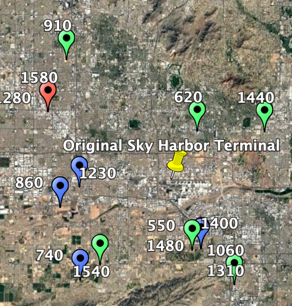
In these overlays, labels show the frequency and radiated power is indicated by three colors of symbols: blue - <4000W, green - 4000 - 20000W, red - > 20000W. The description for each contains the call sign. Ready to use by downloading and then loading into your favorite Electronic Flight Bag application or Google Earth.
The overlays are now organized primarily by chart supplement groups:
| Region | File Name | States |
|---|---|---|
| Alaska | AmStations_AK.kml | AK |
| CONUS | AmStations_CONUS.kml | Continental US |
| East Central | AmStations_EC.kml | IL, IN, MI, OH, WI |
| Hawaii | AmStations_HI.kml | HI |
| North Central | AmStations_NC.kml | IA, KS, MN, MO, ND, NE, SD |
| North East | AmStations_NE.kml | CT, DC, DE, MA, MD, ME, NH, NJ, NY, PA, RI, VA, VT, WV |
| South Central | AmStations_SC.kml | AR, LA, MS, OK, TX |
| South East | AmStations_SE.kml | AL, FL, GA, KY, NC, TN, SC |
| South West | AmStations_SW.kml | ID, MT, OR, WA, WY |